Mission & Technology
Mission
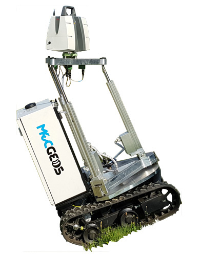
Monitor the Planet revolutionizes the topographic survey method presenting MecGeos®, which stands for Mechatronic for Geodetic System.
It is a robot which can support the Geomatics technician in the field. We are experts in topographic services and in the problems of the present working process which uses the old tripod technology even in the most respected construction sites. MecGeos® robot gives an incredible economic value to geomatics, which is at the heart of infinite sectors: infrastructures, transportation, extracting and mining industry, aerospace, environment, archeology and many others. Monitor the Planet aims to position itself in the deep-tech sector thanks to a breaking innovation which creates a multi-channel marketing, where geo-informatics technologies play a crucial role. Topographic services, which are realized by this advanced concept, are more efficient and successful as well as more beneficial as far as time and money are concerned.
Services
At present, Monitor the Planet provides services for:
- Terrestrial 3D laser scanning
- Land Deformation Monitoring.
- Geospatial Surveying and Mapping.
- Production and post-production 3D modelling, animation and rendering.
The technologies employed
- RTK UAV
- State-of-the-art GNSS
- 3D Laser scanner
- High precision Total Station.
MecGeos reduces problems of geomatic technicians.