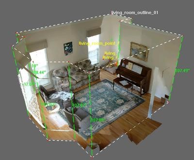
We carry out surveys using laser scanner technology and the creation of 3D drawings, plans and sections, in order to return accurate data of portions of areas in which extraordinary events, crime scenes and / or natural disasters have occurred.
The laser scanner survey, thanks to the creation of a measurable spherical image, allows to analyze details such as traces of braking, position and deformation of objects or vehicles, presence or absence of objects as well as allowing to evaluate each element of the area detected as we were on the spot at the time the event happened.
We carry out surveys using
laser scanner technology and the creation of
3D drawings, plans and sections, in order to return accurate data of portions of areas in which
extraordinary events, crime scenes and / or natural disasters have occurred.
The laser scanner survey, thanks to the creation of a measurable spherical image, allows to analyze details such as traces of braking, position and deformation of objects or vehicles, presence or absence of objects as well as allowing to evaluate each element of the area detected as we were on the spot at the time the event happened.